Before this summer's annual trip to Croatia, I had made up some plans... Two full weeks of 35 degrees (or more) and just not doing anything but spending time in the sun, bathing and drinking coffee at the beach café, makes me a bit fidgety. So the place where we spend our vacations in Croatia is close to the Velebit mountain range and just an hour and a half from the Paklenica NP. I have been in the park before (check this link) but this time the main goal was to reach the highest summit of the mountain range; Vaganski Vhr, which you can reach from the Park, some 1759 m above the ocean (not very high, I know, but still...)
The plan was not very much more complicated than the following: drive, early in the morning, from Pag to Paklenica NP, walk for 6 hours and if the summit was close by then there was no problem but if the summit was still far away I'd have to reassess. But I did not plan for any nights in the park, I was defenitely coming back home to the family in the evening. When studying time-estimates on the map, this should definitely be doable.
I had checked some maps on internet - not real mountaineering maps but actually, they proved sufficient. I just googled Vaganski Vrh map and found some showing the possible trails to go. There were three possible routes to the top: Lipa Staza, Bukova Staza and Struge. Before going there, the plan was to go up via Bukova Staza and down via Struge.
A couple of weeks before the vacation I contacted some friends who where also coming to Pag and asked if they wanted to join me. We were five in the end: Elin, Ola, Darko and Per. Plus myself of course.
We drove from Gajac, on Pag, at four am and reached the parking lot at Paklenica at about half past five. A good time to start as the park is in the shadow of the mountainrange for quite some time. The temperature was very reasonable when we started.
 |
| The parking lot in Paklenica NP - this is where the trail starts |
The first stage of the day was to get to the Paklenica hut, some 250 m up and 6 km away. As we had left early, we stopped after an hour to eat some more breakfast. Just make sure that you stock up on carbs... During the walk, later on, we could se first hand what an effect it has when you're low on carbs.
I must say that having Ola with us was a great comfort as he is one of the most experienced Swedes there are, when it comes to expeditions of any kind (Btw, check out his company's website if you want to get inspired!!). This was obviously not a difficult or very challenging trek for him but for the rest of us I'd say it was at least top five, when it comes to how exhausted we were afterwards. Or at least that is true for me...
 |
| Per, Ola, Elin and Darko are enjoying some real breakfast. |
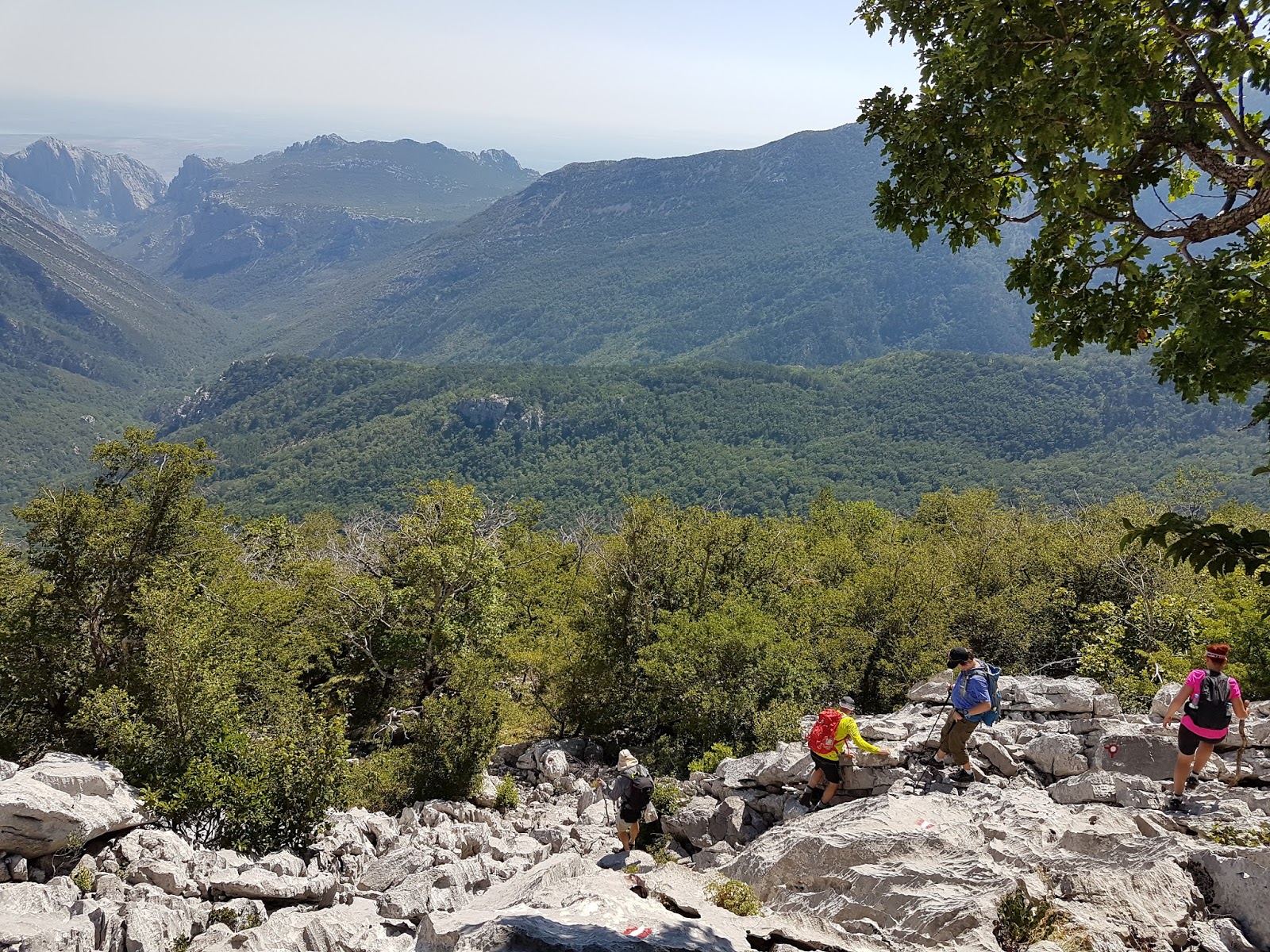
When we reached the Packlenica hut, there was a large map of the tracks of the park and we made the joint decision to change the route. Mostly because it is a bit boring to walk the same way back and forth, which we would have for a bit if we had followed my plan. Instead we decided to go up on the Lipa Staza track, the southernmost track. This proved to be a good decision. So, we started walking... and the track, almost at once, started upwards. At this point, the summit is perhaps 2 km away but we still had about 1100m more in altitude... Since the path is going back and forth a lot on the slope, I guess that in the end we had to walk about 5-6 km more from this point to reach the summit.
 |
| In the center of the photo, perhaps it is possible to see the Paklenica gorge, which we walked up earlier. |
After some three hours we stopped for a little longer to eat, drink and rest a bit. At this point - can be seen in the photo below - the sun is just starting to catch us up. If I remember correctly, this was at about 10:00. So, up until now, we had been able to walk in shadow, which was nice.
As we stopped, I managed to get some photos of the wildlife around us. The Alpine Swifts were common at this altitude and we could also see Rock Bunting and Short-Toed Snake-Eagle here. A litte bit higher up, one of us managed to flush an adult Golden Eagle, which is always an impressive bird. Butterflies were all around but as my camera was mostly in my back pack, I didn't take that many photos of the birds and butterflies. In the end of this post there is a list of the birds seen during this trek and also from Pag.
 |
| Again, the Pakleneca gorge is seen going in between the summits almost all the way down to the ocean. |
 |
| Alpine Swift (alpseglare, Tachymarptis melba) |
This was the first time ever i saw this species. 😊
 |
| Alpine Swift (alpseglare, Tachymarptis melba) |
 |
| Southern Comma (sydlig vinbärsfuks, Polygonia egea |
After this stop, we struggled on. Now the sun was out from behind the mountain range and it got quite a bit hotter. These last 300-400m (altitudewise) were tough... As I mentioned we lost the track which led us to a sort of dead end when we reached the top of this section with slippery little stones. There was a small summit we reached, not the Vaganski Vrh summit, and the only way forward was through a dense patch of low growing Pines. Also, the path forward was sloping down through the pines. But with some scratches we got through this as well and found another path for the very last part of the way to the summit.
At this point, when we started walking upwards again, I must say that I struggled quite much. Even though I thought I was decently in shape, I had felt already from the Paklenica Hut that my thighs were burning (lactic acid) when walking upwards and I at this point I was starting to have trouble keeping up with the rest. Fortunately, the summit was not that far away now and we all managed to reach it well within the expected timeframe.


The view from the summit is really nice, even though when you look at the other peaks close by, they look higher than Vaganski Vrh. Some kind of optical illusion I guess.

An hour or so later, we started heading back. This time via the Struge route. Or at least we started out with the aim to go this route but as Bukova Staza and Struge are the same for some time, we ended up changing that decision when we reached the crossroad. That might have been a bad decision for two reasons. Bukova Staza is decidedly shorter but quite steep and difficult sometimes. Much more so than Lipa Staza. The second reason is that there is a well you can reach when you walk the Struge rute and I was getting low on water. But the shortness of the Bukova Staza won and it started out really nice with walking over some alpine meadows. Up here I managed to see a second bird species I had never seen before, the Alpine Accentor. Not unexpected but definitely not very easy. So, really nice.

Then the trail turned down... In some places, there was no trail. Check the photo below. You can see the red and white train markings in the stone every other meter as the trail was just going straight over the rocks. Some difficult walking but all of us got through it all right. It you discount some blue toe nails...
The irony here is that as difficult as this was, you had to focus on every step in order to not sprain an ankle or worse, a week after this, back in Sweden, I slipped while doing some gardening... I fell dead square on my back, onto a stone, and broke a rib or two...
It all went well and we reached the Paklenica hut, where we treated ourselfs to some well deserved beer or water. We were all pretty worn out at this point and would not have complained if the cars were parked up here. But you should keep in mind that there is another 5-6 km to walk down to the parking lot... To some of us, these last kilometers were actually the worst, as it had felt like we were back when we reached the hut.


After this photo, it was just an easy 1,5 hour walk down to the car. But as said, you should be prepared mentally for it. All in all the walk up and down, including all breaks, took about 13 hours. No one of us got hurt worse than some scratches and blue toenails. I think all of us were quite satisfied when we were back in Pag and had eaten a pizza, in the eavening.
I have not done very much of this before and to me this will be a very nice memory. The Velebit mountain range is beautiful. There is quite a lot to look at if you enjoy wildlife, though we didn't see bears of wolves. I had hoped for some Chamois (Gems) which I had seen there before, but they didn't show. However, quite a few nice bird species and an enormous amount of butterflies.
The rest of the photos below are from around Gajac on Pag. As I always do during our vacations on Pag, I walk around the area during the mornings (not every morning, though...) and check out the local birds. Many nice species, though I have seen them all before. They can be seen every summer. Most of these, I have seen in Sweden as well, but in Croatia they are common and often easy enough to get close to.
Pag:
 |
| European Bee-eater (biätare, Merops apiaster) |
 |
| European Bee-eater (biätare, Merops apiaster) |
 |
| Woodchat Shrike (rödhuvad törnskata, Lanius senator) |
 |
| European Goldfinch (steglits , Carduelis carduelis) |
 |
| Cirl Bunting (häcksparv, Emberiza cirlus) |
 |
| Red-backed Shrike (törnskata, Lanius collurio) |
 |
| Eurasian Hoopoe (härfågel, Upupa epops) |
 |
| European Turtle Dove (turturduva, Streptopelia turtur) |
Birdlist for this year's trip
Paklenica National Park:
Eurasian Nuthatch (nötväcka, Sitta europaea)
Great Tit (talgoxe, Parus major)Grey Wagtail (forsärla, Motacilla cinerea)
Black Woodpecker (spillkråka, Dryocopus martius)
Alpine Swift (alpseglare, Tachymarptis melba) * (means new lifer for me)
Rock Bunting (klippsparv, Emberiza cia)
Short-toed Snake Eagle (ormörn, Circaetus gallicus)
Golden Eagle (kungsörn, Aquila chrysaetos)
Common Kestrel (tornfalk, Falco tinnunculus)
Red Crossbill (mindre korsnäbb , Loxia curvirostra)
Alpine Accentor (alpjärnsparv, Prunella collaris) *
Black Redstart (svart rödstjärt, Phoenicurus ochruros)
Southern Comma (sydlig vinbärsfuks, Polygonia egea) - Butterfly
Pag (birds seen from the road to Gajac and from around Gajac and Kolansko Blato)
Montagu's Harrier (ängshök, Circus pygargus)
European Roller (blåkråka, Coracias garrulus)
Red-backed Shrike (törnskata, Lanius collurio)
Cirl Bunting (häcksparv, Emberiza cirlus)
European Turtle Dove (turturduva, Streptopelia turtur)
Eurasian Sparrowhawk (sparvhök, Accipiter nisus)
Rock Partridge (stenhöna, Alectoris graeca)
European Bee-eater (biätare, Merops apiaster)
Woodchat Shrike (rödhuvad törnskata, Lanius senator)
Spanish Sparrow (spansk sparv, Passer hispaniolensis)
Grey Heron (gråhäger, Ardea cinerea)
Little Egret (silkeshäger, Egretta garzetta)
Pygmy Cormorant (dvärgskarv, Microcarbo pygmeus) in Kolansko Blato
Western Marsh Harrier (brun kärrhök, Circus aeruginosus)
Eurasian Golden Oriole (sommargylling, Oriolus oriolus)
European Shag (toppskarv, Phalacrocorax aristotelis)
Eurasian Hoopoe (härfågel, Upupa epops)
Eurasian Reed Warbler (rörsångare, Acrocephalus scirpaceus)
Inga kommentarer:
Skicka en kommentar